• Skip to primary navigation
  • Skip to main content
  • Skip to primary sidebar
  • ABOUT US
  • MEDIA
  • PRIVACY
  • TERMS
  • DMCA
  • CONTACT US
  • AUTHORS
do you remember

DoYouRemember?

The Home of Nostalgia

  • Celebrity News
    • Family
    • Obituaries
    • Life Behind the Fame
    • ICONS
    • Celebrity Feuds
  • Entertainment
    • Cast
    • Showbiz Rewind
    • Music
    • Beauty & fashion
  • STORIES
  • Celebrity Buzz!?
  • Sitcoms
    • Bewitched
    • Little Rascals
    • The Partridge Family
    • I Dream of Jeannie
    • All in the Family
    • MASH
    • Happy Days
    • Cheers
  • Celebrity Collections
  • SHOP DYR
    • DYR Book

Stories

Solar Eclipse 2017: What You Need To Know

by K. Gitter

Published August 7, 2017

SO IF ECLIPSES HAPPEN EVERY 18 MONTHS OR SO, WHY IS THIS ONE SUCH A BIG DEAL?

It’s because this eclipse is all American: the shadow of the eclipse will pass from the west coast of Oregon all the way to the east coast of South Carolina. It’s the first time a total solar eclipse has passed from one coast to the other in 99 years.

SO WHERE CAN I SEE THIS TOTAL ECLIPSE?

Here’s a trusty map, courtesy of NASA:

Related:

  1. Bonnie Tyler Will Sing ‘Total Eclipse Of The Heart’ During The Solar Eclipse
  2. Gorgeous Photos Of The 2017 Solar Eclipse From Different Areas Across The Country
The path of the total solar eclipse. Image: NASA

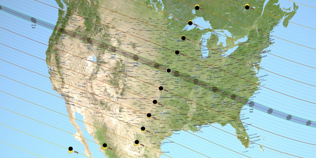
That shaded band cutting across the US is the path of totality — which is about 70 miles wide. That’s the area where the Moon’s shadow will track across the planet’s surface, which is the result of the Moon moving in its orbit and the Earth rotating. Anyone within this region will see the Sun completely covered up for a short period of time.

The shape of the Moon’s shadow won’t be completely smooth. That’s because the Moon isn’t a symmetrical sphere, but is covered in mountains, craters, and valleys. NASA can accurately predict the exact shape of the shadow, thanks to NASA’s Lunar Reconnaissance Orbiter and Japan’s SELENE lunar orbiter — both currently in orbit around the Moon. These spacecraft have taken elevation data of the lunar surface to calculate the shape of Earth’s satellite.

Click NEXT to continue….

Page 2 of 6
Previous article: What’s Wrong with the Picture on the Right?
Next Post: Which is the Correct Top View of this Triangle?

Primary Sidebar

© 2025 DoYouRemember? Inc.

  • about us
  • media
  • privacy
  • terms
  • DMCA
  • CONTACT US
  • AUTHORS